Island birdwatching · England

Birdwatching in Isle of Wight

By Does Your Duck Quack · Planning updated 27 October 2026

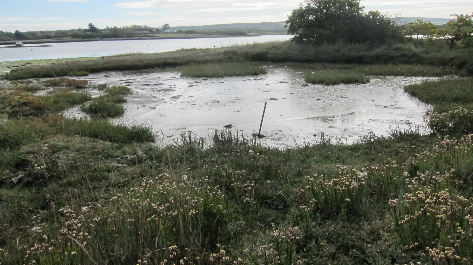
The River Yar valley and Newtown’s tidal harbour make two different foundations for an Isle of Wight birding visit. At Brading Marshes, the route from the town and railway station follows a landscape of wetland and woodland towards Bembridge Harbour. Marsh Harrier, Green Woodpecker and Little Egret feature in the RSPB’s description. Spring brings a vocal element with Cuckoo, Blackcap and Chiffchaff, while Fieldfare and Redwing add winter interest along the hedges. A station-based approach can make the valley walk part of the visit itself. Newtown concentrates attention on saltmarsh, creeks and hide views, with the island bird group identifying Brent Goose, Wigeon and Teal among winter birds. The Trust describes a wheelchair-suitable route to Seabroke hide through Town Copse, but mud can affect the paths. Public parking and toilets serve the reserve visit. Access to those natural habitats is separate from the Old Town Hall, which remains closed for conservation monitoring, so the building’s status does not describe the whole Newtown outing.

Flooded saltmarsh beside the Newtown River, Isle of Wight.
Photo: Flooded saltmarsh adjacent to the Newtown River by Dr Duncan Pepper (resized and converted; social previews may crop) · CC BY-SA 2.0

Birding near a town or postcode →

What to see in October

Green Woodpecker (1 sites)
Little Egret (1 sites)
Marsh Harrier (1 sites)
Pied Flycatcher (1 sites)
Redwing (1 sites)
Water Rail (1 sites)
Read the October birdwatching guide →

Map of Isle of Wight birdwatching sites

Dark green pins are full guides; orange pins are short entries. Numbers match the site lists below. The links show public destinations.

Ventnor Downs1Brading Marshes2St Catherine’s Point3Fort Victoria Country Park4Afton Marsh5Dodnor Creek and Dicksons Copse6Newtown National Nature Reserve7Western Yar Estuary at Yarmouth8
Map base: Spischot and Wikimedia Commons contributors, CC BY-SA 3.0, cropped to the sites. Pins locate destinations, not individual birds.

Worth a special trip

4 short entries · tiers are our editorial assessment; each entry gives its reason and source.

Above Ventnor

  1. 1. Ventnor Downs

    Watch Ring Ouzel, Pied Flycatcher.

    Best season: Spring and autumn migration

    • Parking: Several free car parks are reached from Down Lane.
    • Access: Steep and uneven terrain; no wheelchair-accessible circuit is claimed.
Brading

  1. 2. Brading Marshes

    Watch for Marsh Harrier and Little Egret.

    Best season: Winter flocks; spring migrants

    • Hides: Four open viewing points are listed by the operator.
    • Parking: Parking is available at Brading station and in the town.
    • Access: Routes are uneven and can be muddy or slippery; wheelchair-suitable…

Niton

  1. 3. St Catherine’s Point

    Watch Red-throated Diver, Gannet in rocky coastline.

    Best season: Winter coastal movements; spring and autumn migration

    • Parking: The National Trust directs Point visitors to the car park…
    • Step-free: Cliff paths can be muddy, slippery and very windy; no…

West of Yarmouth

  1. 4. Fort Victoria Country Park

    Watch for Common Scoter, Gannet.

    Best season: Winter coastal movements; spring and autumn passage

    • Parking: Free parking at the end of Westhill Lane; entrance height…
    • Step-free: Ask the park about the suitability of individual woodland paths;…

Good stop nearby

4 short entries · tiers are our editorial assessment; each entry gives its reason and source.

Freshwater

  1. 5. Afton Marsh

    Listen along the fen-edge path near Freshwater Bay.

    Best season: Check water levels; source names breeding birds without months

    • Parking: Freshwater Bay has a council long-stay public car park.
    • Step-free: Wet fen paths and flooding can limit the accessible route;…

North of Newport, Medina estuary

  1. 6. Dodnor Creek and Dicksons Copse

    Look for Water Rail.

    Best season: Summer for Swallow and Swift; autumn and winter for Water Rail

    • Parking: Some parking is available at the riverside picnic site on…
    • Access: The council marks uneven paths and slopes; the cycleway offers…

Town Lane, Newtown

  1. 7. Newtown National Nature Reserve

    Scan Newtown’s creeks and mudflats from the marked public routes.

    Best season: Winter waterbirds; check tide and path conditions

    • Hides: Public bird hides include Seabroke hide.
    • Parking: Paid visitor parking uses JustPark; members must register.
    • Access: The Trust identifies a wheelchair-suitable route through Town Copse to…

Yarmouth

  1. 8. Western Yar Estuary at Yarmouth

    Scan Yarmouth’s tidal estuary from public paths.

    Best season: Winter ducks and waders

    • Parking: River Road is a council long-stay public car park.
    • Access: The harbour describes an easy-access circuit, but road stretches and…

Reserve operators and local visitor information

Getting to the birdwatching sites

Brading Marshes: Brading railway station provides a practical starting point for exploring the marshes on foot. Read the visitor access notes.

Newtown National Nature Reserve: Use Town Lane and the brown reserve signs from the A3054. The Trust’s Newport–Yarmouth bus option leaves a walk from Shalfleet; check the actual return journey. Read the visitor access notes.

Where to stay in Isle of Wight

Some links earn us a small commission at no extra cost to you. Bases are geographical suggestions, with no claim of property inspection or availability.

Brading

Compare Brading Marshes and Newtown National Nature Reserve from Brading.

  • Brading Marshes: approximately 2 minutes / 0.3 miles by road. Measured 2026-10-26; excludes traffic, parking and walking. Open road directions

    Brading station arrival; explore the marshes on foot. Mainland ferry excluded.

  • Newtown National Nature Reserve: approximately 22 minutes / 14.1 miles by road. Measured 2026-10-26; excludes traffic, parking and walking. Open road directions

    Newtown Town Lane visitor-parking approach. Mainland ferry excluded.

Find stays in Brading on Booking.com

Sandown

Compare Brading Marshes and Newtown National Nature Reserve from Sandown.

  • Brading Marshes: approximately 6 minutes / 2.0 miles by road. Measured 2026-10-26; excludes traffic, parking and walking. Open road directions

    Brading station arrival; explore the marshes on foot. Mainland ferry excluded.

  • Newtown National Nature Reserve: approximately 24 minutes / 15.0 miles by road. Measured 2026-10-26; excludes traffic, parking and walking. Open road directions

    Newtown Town Lane visitor-parking approach. Mainland ferry excluded.

Find stays in Sandown on Booking.com

Newport (Isle of Wight)

Compare Brading Marshes and Newtown National Nature Reserve from Newport (Isle of Wight).

  • Brading Marshes: approximately 15 minutes / 8.3 miles by road. Measured 2026-10-26; excludes traffic, parking and walking. Open road directions

    Brading station arrival; explore the marshes on foot. Mainland ferry excluded.

  • Newtown National Nature Reserve: approximately 10 minutes / 6.1 miles by road. Measured 2026-10-26; excludes traffic, parking and walking. Open road directions

    Newtown Town Lane visitor-parking approach. Mainland ferry excluded.

Find stays in Newport (Isle of Wight) on Booking.com

Questions visitors ask

Where can I start birdwatching in Isle of Wight?

Ventnor Downs: Watch Ring Ouzel, Pied Flycatcher. Brading Marshes: Watch for Marsh Harrier and Little Egret.

Which birds are associated with these Isle of Wight sites?

Ventnor Downs: Ring Ouzel — Spring: March–June; Pied Flycatcher — Autumn: July–mid November; Wheatear — Spring: March–June. Brading Marshes: Marsh Harrier — Typically year-round; Little Egret — Typically year-round; Green Woodpecker — Typically year-round.

How do I reach these birdwatching places?

Ventnor Downs: Turn from Newport Road into Down Lane opposite the cemetery and continue to the downs. The National Trust’s Views of Ventnor walk supplies the public arrival grid reference SZ565784. Brading Marshes: Brading railway station provides a practical starting point for exploring the marshes on foot.

What visitor facilities are described?

Ventnor Downs: Several free car parks are reached from Down Lane. Brading Marshes: Parking is available at Brading station and in the town.

What access information should I check?

Ventnor Downs: Steep and uneven terrain; no wheelchair-accessible circuit is claimed. Brading Marshes: Routes are uneven and can be muddy or slippery; wheelchair-suitable trails are not provided.

Can I bring a dog to these places?

Ventnor Downs: Keep dogs close; use short leads around livestock and follow nesting-bird lead signs. Brading Marshes: Dogs must stay on designated paths, on short leads.

Social preview photograph: Flooded saltmarsh beside the Newtown River, Isle of Wight. Flooded saltmarsh adjacent to the Newtown River by Dr Duncan Pepper · CC BY-SA 2.0. Resized and converted for the preview.

Sources for planning a Isle of Wight visit

Plan the next part of your visit